The Soils4Africa project has produced a ‘map of agricultural land of continental Africa.’ The map depicts the distribution of agricultural land (land used for growing crops, grazing livestock, and various other agricultural uses) across the continent. It will be used by the project as basis for the selection of the 20,000 sites where it will collect soil samples, which will be analysed to produce the baseline data for a continental-level soil information system (SIS). The SIS will help improve the targeting and monitoring of interventions to boost sustainable intensification of agriculture in Africa. (Read more about the project >>)
Building upon Copernicus Global Land Cover Data
The map is based on Copernicus Global Land Cover data which shows actual land cover (what physically covers land across the globe—forests, grasslands, croplands, lakes, wetlands, built-up area, etc) at 100m x 100m resolution. The land cover data for Africa was overlaid on (high resolution) satellite imagery of Africa, which is then used to determine the land use (by visual interpretation) associated with the various land cover patterns on the Copernicus Global Land Cover map.
Copernicus land cover data offers several advantages: it is of high quality, has a high resolution (100m x 100m), and offers time series satellite imagery. More importantly, the Copernicus Global Land Service is a continuous process and its datasets are updated annually. This means that the Soils4Africa map of agricultural land can be updated every time the land cover data for the new year becomes available (the map is currently based on 2019 data).
The Copernicus dataset already includes the category ‘cropland,’ which by definition is part of agricultural land. The Soils4Africa map broadens the scope of that dataset by infering information on agricultural use and including other kinds of agricultural land use such as grazing pastures and plantations.
When land is mapped as other than ‘cropland'-- like ‘shrubland’ for example-- it is more difficult to interpret and determine whether it is under agricultural use. The Copernicus dataset includes information about ‘fractional cover’-- or the percentage of a particular pixel under a particular kind of land cover (for example, 30% of a 100m x 100m pixel could be forest and 20% could be shrubland). The Soils4Africa map takes into account how fractional cover varies over an area to establish rules for interpreting its land cover data to determine whether it is under agricultural use and for what purpose. These rules were validated by comparing it with ground level information on land use (or land use pattern) for specific areas drawn from the interpretation of satellite imagery from Google Earth.
For example, ground-level observation shows that forest cover upwards of 30% in a given area when matched by shrubland cover of over 30%, is characterized by woody vegetation with a smooth canopy. Therefore, such area is more likely to be under plantations rather than natural forest. Thus, such an area should be counted as agricultural land, even if less than 15% of it is under crops.
The inference rules used for the map are presented in this report (Download Here; please note this report has been updated on 05/01/2023 with an additional annex). They can be applied to other land cover datasets, provided that they are validated and adjusted to account for any differences between their land cover classification system and that of the Copernicus Global Land Cover map.
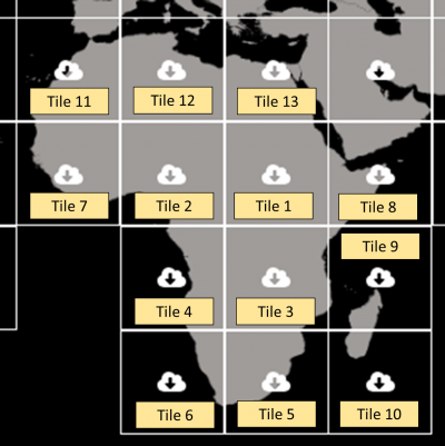
Copernicus data for Africa is organized into tiles of 20 by 20 arc degrees. The inference rules were formed based on Copernicus data and Google Earth imagery mainly for the area enclosed within Tiles 1, 2, and 7 (covering central and west Africa), and results were validated for the remaining tiles. Tile 1 covers the geographical area from the center of the Democratic Republic of Congo in the southwest to the Red Sea off the coast of Eritrea in the northeast. It spans most of the agroecological zones of Africa from the tropical humid forest in DRC to the tropical-arid regions of Sudan and the tropical highland areas of Ethiopia. Also, most of the land use types typical of Africa are represented in this area. The rules were then extrapolated to data from other tiles to derive the map of agricultural land over rest of the continent.
Copernicus Global Land Cover map tiles (20 arc degrees * 20 arc degrees)
Map Specifications
The map is available in Geotiff file format, in a 100m x 100m resolution (corresponding to the resolution of the Copernicus dataset). It can be downloaded from here: version 1, version 2(DISCLAIMER: The map is under review and subject to changes if deemed necessary. As such, the European Commission and European Research Executive Agency are not responsible of the content of the documents. Any subsequent updates will be shared and flagged as such. )