<< Back to News
Why we are building a Soil Information System for Africa
November 13, 2020
With inputs from Jeroen Huising, Bas Kempen, and Mary Steverink-Mosugu
Data drives our lives the way oil once did, leading many to
posit that ‘Data is the new oil.’ Digitalisation has led to the generation of unprecedented volumes of data—related to how we travel, what we buy, how we vote, what we like, and so on. Governments and corporations base their strategies and activities on mining and analysis of such data. In fact, such is the abundance of data and its mining that privacy and data protection of individuals is a now a big concern.
At the same time, there are aspects of our lives and regions of the world where good quality/ actionable data is scarce and/or outdated. A case in point is soil data in Africa, key to ‘Sustainable Intensification’ of agriculture in the continent—or maximizing agricultural output while using soil and water sustainably (with respect to overuse and climate change effects). One needs good quality soil information to plan the most efficient use of fertilizers, to choose the right seed varieties, and to determine the best water management measures for a given area.
Limitations of existing African soil data
A fair amount of soil data exists at national and regional levels across Africa. However, the various datasets are difficult to combine and compare with each other, as they have been collected using different methodologies and exist in a wide range of formats. Much of the data is not digitized and cannot be fed into models and databases except manually. A lot of the data was collected before GPS technology was widely accessible, so the geo-referencing can be inaccurate. The metadata are often not well documented, so methods and standards applied for collection of the data are difficult to trace.
The Africa Soil Information Service (AfSIS) project (2009-2016) was a big step towards improving upon this situation. It compiled existing (legacy) soil data from across 300 sources representing 18,000 locations across Africa and harmonized it into one common, digital format. Additionally, new samples were collected from about 9,000 locations spread across sixty 100km2 sites across Africa. This dataset was used to construct pan-Africa soil maps, using digital soil mapping techniques and geostatistical methods, providing soil data which could be visualised at a resolution of up to 250 m. AfSIS also formed the basis of SoilGrids, a global-level digital soil modelling and mapping system.
While such compilation of legacy data is a great improvement upon the previous situation, it is still limited by incompatibilities between the different datasets it draws on. Thus, it does not make for a suitable basis to monitor future changes in soil properties at (sub)continental scale.
Soils4Africa Project
AfSIS and SoilGrids are key take-off points for the Soils4Africa project, which aims to develop a continental-scale Soil Information System (SIS), built upon a baseline of primary soil data collected from 20,000 locations across Africa. The methodologies behind the SIS will be based on those of
LUCAS, the land and soil monitoring system of the European Union.
Equally importantly, it will develop standard methodologies for collecting soil samples and analysing them in the laboratory. Such standardization will ensure that the resulting continent-wide dataset will be robust, and that sampling and analysis can be repeated to enable monitoring of soil quality over time. Such monitoring will help ascertain the effect of different kinds of land uses and intensification measures on different kinds of soils. Standard, repeatable methodologies can also be used to continually grow the database and add data points for the monitoring of soil quality at sub-regional, national and local level.
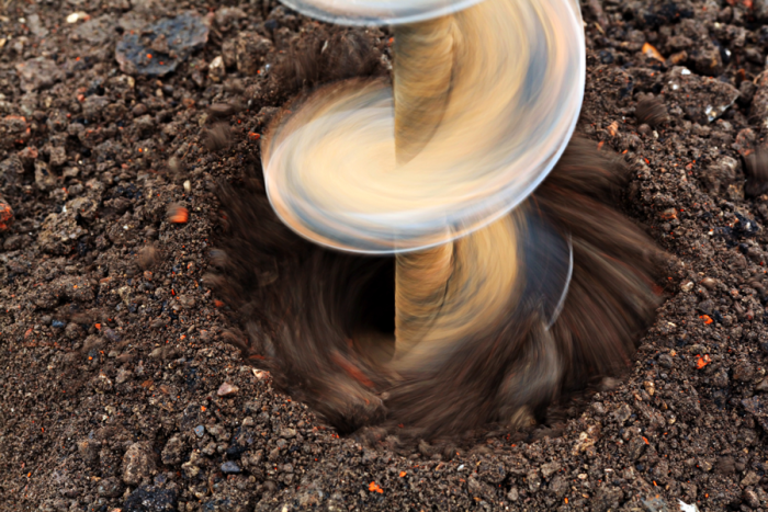
The project kicked-off in September 2020. One of the activities now underway is design of a process for selecting the 20,000 sites where soil samples will be collected—during the project, as well as repeatedly in the future for monitoring changes in soil properties. This is crucial, as one has to ensure that the selected sites represent the major agro-ecological zones and farming systems in Africa.
The samples will be analysed for texture, pH, organic carbon, carbonate content, phosphorous content, total nitrogen content and extractable potassium content. All topsoil samples will be analysed for heavy metals. 300 select samples will be analysed for pesticide residues. Additional parameters will be included based on findings from consultations with a wide range of soil information users.
A map of agricultural land in Africa
Part of the process will be preparing a map of agricultural land in Africa. The difficulty here is that land use in Africa is very mixed. Agricultural land is found across various land cover types. For example, field patterns may or may not be clearly visible and parcels may be scattered within the landscape. Thus, it is difficult to delineate agricultural land in satellite images. While such maps do exist, they put cropland at less than 10% of the land surface in Africa. We know from ground-level experience that this is likely an underestimate. Hence the imperative to make a new map that can guide the soil sampling exercise more accurately.
Thus, the project will be considering fractional cover, or ‘cropland probability’, and is working towards a formula to more accurately identify agricultural land. The spatial pattern must be an important criteria to determine the probability of cropland or of cultivated land in general, and to identify that part of land as agricultural area. Pixels with Cropland Probability higher than a certain threshold will be considered to be croplands and considered as potential soil sampling sites.
Connect with us
Building a continental-wide Soil Information System is a large undertaking, reflected in the large number and wide variety of
partner organisations in the project, from across Africa and Europe. Across its various activities, the project will engage a wide range of organisations who deal with soil information— universities, government organisations, agribusinesses, extension organisations, NGOs, etc.
If you would like to connect and know more please write to us at info@soils4africa-h2020.eu